
Tropical Storm Bertha has intensified in the northeastern Gulf, and it is projected to bring rain, strong winds, and coastal flooding to various areas of the Gulf Coast, stretching from Florida to Louisiana.
🌀 ⛈️ Access your storm forecast via the USdaily Weather app
The maximum sustained winds of Bertha increased from 50 mph to 60 mph late Tuesday morning; however, the storm is not anticipated to experience significant changes in strength for the remainder of the day.
Although Bertha has gained strength, it remains poorly organized. Its thunderstorms are primarily located in its southern half due to adverse upper-level winds and dry air that hinder development, despite the presence of near-record warm waters in the Gulf.
This imbalanced structure is likely to keep much of Bertha’s heaviest rainfall and strongest winds offshore as it moves westwards along the northern Gulf Coast through Wednesday.
Nevertheless, the National Hurricane Center indicated that tropical storm conditions are starting to reach the immediate coastline of the Florida Panhandle by Tuesday afternoon. The storm is also sending bands of rain and rough surf towards parts of the northern Gulf Coast.
The moisture from Bertha will also contribute to a flooding rain risk hundreds of miles away in the Southeast. A stationary cold front in this area will draw moisture from the Gulf between Wednesday and the end of the week, particularly affecting the Carolinas and southeast Virginia.
Bertha is the second named storm of this year’s Atlantic hurricane season, which has had a slower start compared to previous years as El Niño strengthens its influence in parts of the basin.
The National Oceanic and Atmospheric Administration anticipates a below-average number of named storms in the Atlantic this season due to these conditions.
Storm track, intensity
Bertha is expected to move along the Gulf Coast and make landfall or skim the southeastern coast of Louisiana by early Wednesday evening as a weakened tropical storm.
Following that, Bertha is projected to head towards the Upper Texas Coast, gradually weakening into a tropical depression later this week, although it may not reach that far west. The wind shear currently affecting Bertha could lead to its early dissipation near the Louisiana coastline.
Wind shear refers to the variation in wind speed or direction in the upper atmosphere that can tear storms apart. This phenomenon is also why most of Bertha’s thunderstorms are positioned to the south of its center.
Interaction with land along the Gulf Coast will further exacerbate the unfavorable conditions by removing the warm, moist ocean environment that sustains Bertha’s thunderstorms.
Expected impacts on Gulf Coast
Regardless of the storm’s outcome, the northern Gulf Coast will experience bands of rain, strong winds, and some coastal flooding through at least Thursday.
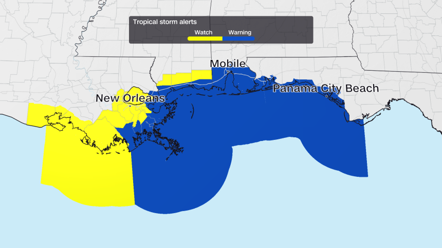
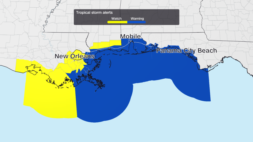
A tropical storm warning has been issued for the western Florida Panhandle, coastal Alabama, Mississippi, and southeastern Louisiana. In these regions, tropical storm conditions—sustained winds of 39 mph or more—are anticipated within the next 36 hours. Tropical storm watches extend as far west as south-central Louisiana.
Anticipated outcomes include:
• Precipitation: Rainfall amounts ranging from 1 to 4 inches are expected, with isolated areas possibly receiving up to 6 inches during the most intense thunderstorms, affecting the western Florida Panhandle, southern Alabama, Mississippi, Louisiana, and possibly the Texas coast. This could lead to localized flash flooding, particularly in urban centers like New Orleans.
• Winds: Tropical storm conditions with sustained winds of 39 mph or greater are anticipated in the warning area encompassing the western Florida Panhandle, Alabama, Mississippi, and southeastern Louisiana from late Tuesday into Wednesday. Stronger gusts in thunderstorms may lead to isolated power outages.
• Storm surge: Water levels may increase by 2 to 4 feet above the normal levels from the mouth of the Mississippi River in southeast Louisiana to the Alabama-Florida border, particularly during the high tides on Wednesday and Thursday mornings. A coastal flood warning has been issued for southeast Louisiana and Mississippi coasts, where moderate coastal flooding is likely in low-lying regions.
• Hazardous beach conditions: Choppy surf and a heightened risk of rip currents will persist along beaches from the Florida Panhandle extending west to Alabama, Mississippi, and Louisiana through at least Thursday. These conditions pose life-threatening risks even for the most capable swimmers.
